
The Importance of the Gulf Stream Encounter in Navigating to Bermuda
Learning Objectives
- Understand the structure and behavior of the Gulf Stream (GS) and associated eddies
- Learn how to integrate current data with weather routing
- Interpret Sea Surface Temperature (SST) and Sea Surface Height (SSH) data and their respective strengths
- Evaluate agreement between forecast models (RTOFS, Mercator) and observations
- Apply ocean current data effectively within routing software
Successful navigation to Bermuda must take Gulf Stream currents into account as part of the overall routing strategy. Regardless of the software used, it is critical to incorporate forecasted ocean currents and wind to develop an optimal route.
The Gulf Stream (GS) flows northeast along the eastern seaboard of the United States before turning eastward, beneath the continental shelf south of Newport. With currents reaching up to 5 knots, the GS is not to be underestimated. A favorable meander can provide a significant tail current, accelerating the passage to Bermuda. However, poor positioning can result in battling a head current of similar strength—or worse, encountering wind against current and the resulting treacherous seas.
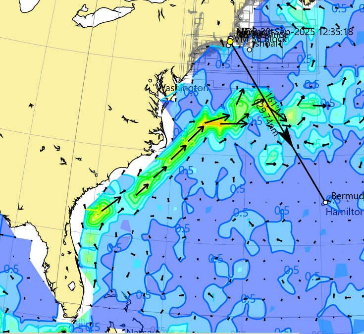
Gulf Stream (green yellow) moving in a NE direction then turns east and maenders near the rhumbline(black line) of the Newport Bermuda race.
In addition, eddies break off from the Gulf Stream. North of the stream are warm-core eddies, while south of the stream are cold-core eddies. It is essential to understand both their location and rate of movement, which is typically westward. Being on the wrong side of an eddy can mean prolonged adverse current, while becoming trapped within an eddy in light winds can result in slow, circular drift.
Two additional cautionary notes: the Gulf Stream generates its own localized weather due to warm water interactions, and when wind opposes current, dangerous, steep, short period “square” waves can develop. I remember my first transit of the GS, I was in beautiful weather and on the horizon was a line of thunderstorms positioned over the GS.
An essential part of a navigator’s task is to understand not only the predicted winds but also the currents the vessel will encounter. Fortunately, it is relatively straightforward to download GS current models that can be incorporated into routing calculations (A separate blog will cover how to obtain weather and current data). These models are derived from satellite measurements of either Sea Surface Temperature (SST) or Sea Surface Height (SSH).
SST identifies the warm water mass of the Gulf Stream—for example, temperatures may be around 78°F within the stream, dropping to near 58°F just a few nautical miles away. SSH data reflects slight variations in sea level caused by ocean dynamics; where currents exist, the water surface is subtly elevated. These variations allow altimetry to estimate current speed and direction.
In preparation for a race, it is valuable to study the Gulf Stream and its eddies over time, observing how they move and evolve. Eddies generally, though not always, move at a slow rate in a westerly direction.
SST data requires clear skies and can be limited by cloud cover, particularly in spring. In contrast, altimetry measurements penetrate cloud cover and provide consistent, reliable SSH data that is interpreted into current rate and direction.
In the lead-up to an ocean passage to Bermuda, I rely on both observational data (SST and SSH) and forward-looking current models such as RTOFS and Mercator, which incorporate these data sources. Altimetry helps answer: Where is the Gulf Stream now, and how has it evolved over the past two to three months? The RTOFS and Mercator models are then used to project how the system is likely to evolve during the passage.
I look for agreement between models. If RTOFS and Mercator align, confidence in the forecast position of the Gulf Stream is high. If they diverge, I compare each model against current SST and SSH to determine which is more accurate. For example, if RTOFS aligns closely with observed SSH, I place greater trust in its forward projections.
Eddies can be difficult to resolve in RTOFS and Mercator models, but they are clearly visible from SSH data. Because they move relatively slowly, it is often possible to predict their position during the voyage and determine whether they can be used advantageously—or should be avoided.
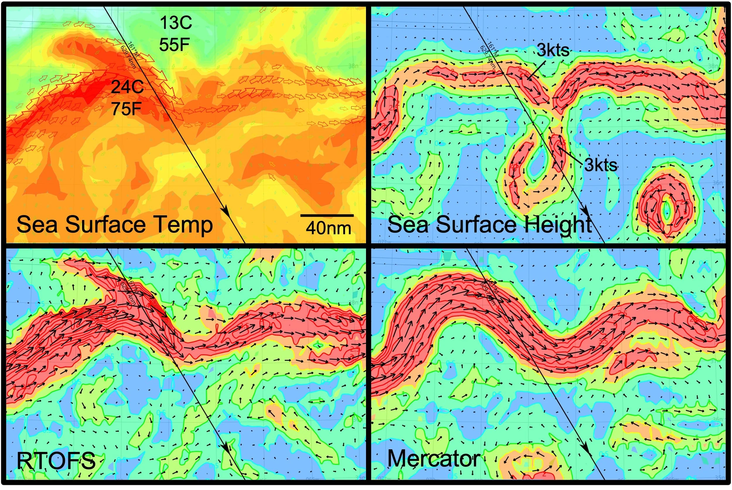
Top row: observation data, Sea Surface Temperature, and currents calculated from Sea Surface Height (altimetry). Lowe row": RTOFS and Mercator models of currents on the rhumbline to Bermuda.
A Comparison of Ocean Currents Derived from Data and Models
In this example, I compare current data with forecast models to highlight key features relevant to routing (data obtained March 22, 2026). A portion of the North Atlantic Ocean is shown, and the rhumb line from Newport to Bermuda is depicted as a diagonal black line.
The top row shows observational data, while the lower row shows model output. The SST (top left) clearly reveals the northern wall of the Gulf Stream and the associated temperature gradient, allowing visualization of the stream’s general path. The SSH data shows a similar pattern near the rhumb line.
In the lower row, the RTOFS and Mercator models are shown for the same day. All four images display a broadly similar pattern for the Gulf Stream’s course, with relatively good agreement. However, RTOFS appears to align more closely with the SST and SSH data.
What is strikingly different is the ability to resolve eddies. SSH is particularly effective at identifying their positions. If one were to rely solely on RTOFS or Mercator, one might follow the strong southeasterly current of the Gulf Stream to gain speed. However, SSH reveals that this path may soon encounter adverse current from an eddy located along the rhumb line. (Note the eddy near the rhumb line formed in May 2025.)
There are limitations to both forward-looking models, while SSH provides only current conditions rather than forecasts. How should one proceed? With ocean current data, it is possible to instruct routing software to “extend current in time.” Using SSH data—which effectively identifies eddies—routes can be calculated even without a formal forecast. This approach assumes that the position of the Gulf Stream and its eddies does not change rapidly.
Unlike surface winds, the Gulf Stream and its eddies evolve relatively slowly. Altimetry data can be examined over time by reviewing historical datasets. For example, weekly intervals through February 2026 show that eddies near the rhumb line on March 22 remained in roughly the same position for weeks. This stability suggests that their positions will not change significantly over the one to two days required to reach the Gulf Stream from Newport.
Therefore, it is reasonable to extend altimetry-derived current data forward in time within routing software, allowing these currents to be incorporated into route optimization.
The key question for the navigator becomes:
i) Should you use the southeasterly flow of the Gulf Stream and then continue southeast to avoid the adverse current of the eddy?
ii) Or should you route west of the rhumb line, cross the easterly flow of the Gulf Stream, and then ride the western side of the eddy?
The answer depends on several factors: boat speed, tolerance for current (e.g., is a 3-knot adverse current significant for your vessel?), and the wind forecast. Wind direction, boat polars, and current all interact to determine the optimal route.
Finally, one must have a compelling reason to route east of the rhumb line in this race, given that prevailing winds are typically from the southwest..
Sailor Takeaway
- Always include current alongside weather in routing
- Use SST to locate the Gulf Stream; use SSH (altimetry) to identify eddies
- Trust models when they agree—but validate them against observations
- Eddies matter: they can help or hurt
- The Gulf Stream evolves slowly—use historical altimetry to project forward
- Routing is a balance of wind, boat performance, and current—not any one factor alone