
Elements of a Sailboat Routing Plan
Teaching Objectives
1) Understand the four core components of a routing plan
2) Explain how routing software uses isochrones to determine optimal paths
3) Describe the role of ocean current models, including altimetry
4) Critically evaluate routing outputs rather than relying on them blindly
5) Recognize when strategic simplicity (e.g., staying near rhumb line) may outperform model-driven routes
Developing an effective sailboat routing plan requires integrating four essential components:
1. Routing Software
Software with integrated marine charts that allows the user to define departure and destination points.
2. Weather Forecast Data (GRIB Files)
Forecast wind speed and direction obtained from GRIB (Gridded Binary) files.
3. Ocean Current Data
Information on tidal flows and major currents such as the Gulf Stream.
4. Boat Performance Data (Polar Files)
A polar file describes how fast the boat sails at different wind speeds and angles.
Once a start time is defined, routing software combines these elements—boat performance, forecast winds, and currents—to calculate the fastest route to the destination.
Routing Software
My introduction to route planning began with qtVlm, a free routing software developed in France and available for Mac and PC, with low-cost mobile versions. Its key advantages are:
- No cost for entry-level routing
- Availability across devices, providing redundancy if a navigation computer fails
Even though I now primarily use more advanced software, I still keep qtVlm on my phone and tablet as a reliable backup. Other commonly used routing platforms include Expedition and Adrena. Regardless of the platform, all routing software follows a similar computational approach.
Isochrone-Based Routing
Routing software works by calculating isochrones—the set of positions a boat can reach after a fixed time interval (e.g., 60 minutes) when sailing in multiple directions.
- From each position, the software repeats the calculation
- This creates a branching set of possible paths
- The optimal route is selected based on the shortest time to destination
This iterative process accounts for wind, currents, and boat performance.
Weather GRIB Files
Wind data is obtained from GRIB files, which provide forecasted wind speed and direction.
Within software like Expedition, multiple models can be used, including:
- GFS (Global Forecast System)
- ECMWF (European model)
GRIB files can be downloaded via:
- Saildocs (free)
- PredictWind (subscription-based)
Using multiple models allows for comparison and improved decision-making.
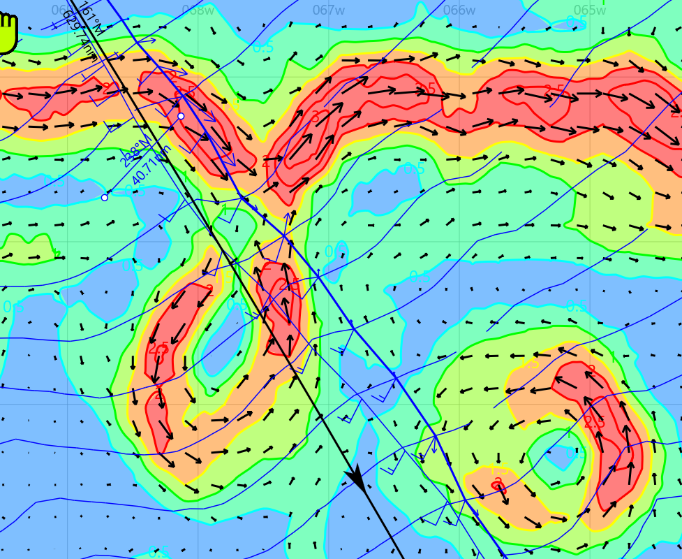
Ocean Currents
Ocean current data can be accessed similarly to GRIB files, either through routing software or external services like Saildocs.
A particularly valuable source is satellite-derived altimetry, which provides:
- Sea Surface Height (SSH)
- Derived current estimates
This is especially useful for identifying Gulf Stream eddies, which can significantly impact routing decisions. Future articles will discuss comparison of currents from different models as well as how to obtain currents from altimetry information.
Performance Polar of the Boat
A boat’s speed depends on:
- True Wind Speed (TWS)
- True Wind Angle (TWA)
These relationships are captured in a polar file, which the routing software uses to estimate speed and distance traveled.
For example:
- At TWA = 60° and TWS = 15 knots → boat speed ≈ 8.31 knots
- At TWA = 90° and TWS = 15 knots → boat speed ≈ 9.16 knots
By applying these calculations across many conditions, routing software determines optimal paths over time.
Example: Routing to Bermuda
To illustrate the importance of these inputs:
- Routing using wind data only produces one optimal path
- Routing using both wind and current data produces a different path
Two routes are shown: thin blue line without currents, thibk blue line with currents. Note that the routing avoids the northerly adverse current.
When overlaying the routes on a current map the software avoids adverse currents (e.g., north-flowing eddies) and may choose a longer geometric route for a faster overall time
Critical Judgment
Routing outputs should not be followed blindly.
Key questions to ask:
- Is the predicted time gain meaningful?
- Does the route significantly increase distance sailed?
- What are the risks of deviation from the rhumb line?
In one race, I chose to stay near the rhumb line while others diverted to chase favorable current. In that case, staying direct proved faster.
Sailor Takeaway
- Routing software is a powerful decision-support tool—but not a decision-maker.
- The fastest route is not always the one suggested by the model.
Successful sailors combine routing outputs with judgment, experience, and risk awareness.
- Use the software to inform your thinking—never to replace it.